|
|
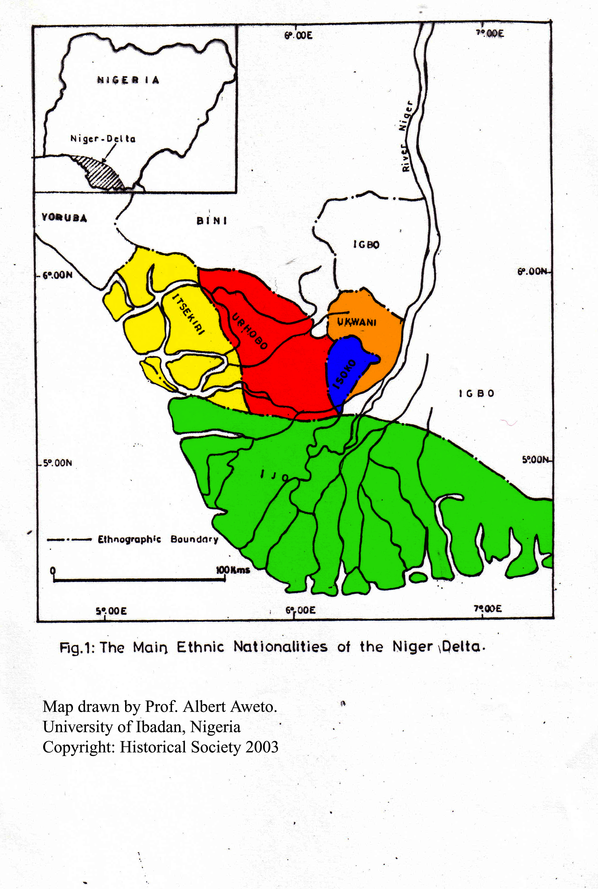
OUTLINE GEOGRAPHY
OF
URHOBOLAND
By Albert Aweto, Ph.D.
Professor of Geography
University of Ibadan, Nigeria
(January 31, 2002)
|
Location: Western Niger Delta Area: 5000 square kilometres Population: 1.5 million Main towns: Warri, Sapele, Ughelli Climate: Humid subequatorial Natural vegetation : Rain forest/ swamp forest Minerals: Oil, natural gas Main rivers: Ethiope, Warri, Kiagbodo |
INTRODUCTION
The Urhobo people are one of the major ethnic nationalities of the
Niger delta. They live in the western part of the Niger delta, the
salient features of which essentially encapsulate the geography of
Urhoboland. The location of Urhoboland in a delta has not only
influenced the nature of the physical environment but also the mode of
life of the people. The population of Urhoboland was 1.12 million in
1991. Today, the population is about 1.5 million.
LOCATION
Urhoboland is located in the western part of the Niger delta , south
of latitude 6° N. It is a
contiguous territory of about 5000 square kilometres in the southern
part of Delta State of Nigeria. It is bounded by latitudes 5
°
15' N and 6° N and
longitudes 5° 40' E and
6° 25' E.
PHYSICAL ENVIRONMENT
(a) Relief
The whole of Urhoboland is a low-lying plain consisting mainly of
recent unconsolidated sediments of Quaternary age. These sediments are
partly of marine and partly of fluvial origin. Land elevation is
generally under 50 meters above mean sea level and there is a marked
absence of imposing hills that rise above the general land surface. The
area is traversed by numerous flat-floored rivers that drain into the
Atlantic Ocean. The most important rivers are the Ethiope, Warri and the
Kiagbodo. These rivers are prone to flooding, especially during the wet
season, mainly because of the heavy rainfall, high ground water table
and the flat-floored valleys. Large stretches of most rivers, especially
the lower reaches of the Ethiope, Warri and the Kiagdodo rivers are
permanently waterlogged.
(b) Climate
As with the rest of the Niger delta, the climate of Urhoboland is humid
subequatorial with a long wet season lasting from March to October that
alternates with a shorter dry season that lasts from November to
February. The climate is influenced by two prevailing air masses namely
(1) the S. W. monsoon wind and (2) the N. E trade wind. The former
prevails during the wet season and the latter during the dry season. The
S.W monsoon winds originate from the Atlantic Ocean and they are
associated with the wet season, being warm and moisture-laden. In
contrast, the N.E. trade winds originate from the Sahara desert and
their prevalence is associated with the dry season. The effects of the
dry N.E. trade winds are most noticeable in Urhoboland from December to
February when they usher in the dry and dusty harmattan. Annual rainfall
is high throughout Urhoboland, being usually up to 2500 mm. In southerly
locations such as Warri and Ughelli, mean annual rainfall is up to 2800
mm. The beginning and end of the wet season are usually marked by
intense thunderstorms of short duration, often accompanied by strong
winds which may blow off roofs of buildings and cause destruction of
property. Prolonged and gentle showers, usually lasting several hours or
a few days, are more characteristic of the middle of the wet season. The
rainfall regime is double-peak, the two periods of peak rainfall being
June/July and September which are separated by a relatively dry period
in August. Annual temperature average in Urhoboland is about 27
°C with no marked seasonal departure from the average temperature as the
annual range of temperature is quite small, rarely exceeding 3
°C.
(c) Vegetation
The natural vegetation of Urhoboland is rain forest with swamp forest
occurring in flat-floored valleys and adjoining low-lying areas that are
seasonally or permanently waterlogged. The rain forest is floristically
diverse and structurally complex, with several layers of trees. It was a
major source of timber and the notable timber-producing species
include
Antiaris toxicaria, Milicia (Chlorophora) excelsa, Ceiba pentandra
and Piptadeniastrum africanum. Other trees that feature in the
rain forest include
Pentaclethra macrophylla, Chrysophyllum albidum and Irvingia
gabonenesis.
The two last mentioned tree species are fruit trees which are important
as sources of income and dietary supplement for rural people. Virtually
all the rain forest in Urhoboland has been destroyed as a result of
farming, especially shifting cultivation and the establishment of
small-scale holdings of rubber trees, coupled with commercial lumbering. Today, much of the countryside is
dominated by secondary regrowth vegetation with
oil palms (Elaeis guineesis
) and Chromolaena odorata, farmland, rubber "plantations" and
patches of swamp forest along rivers. Unlike rain forest, fairly large
areas of land are still under swamp forest vegetation in Urhoboland
today. This is mainly because the swampy terrain of areas under swamp
vegetation hinder access and make cultivation and timber exploitation
difficult. Extensive areas of swamp forest occur in the Urhobo- Okpe
forest reserve, south of Sapele, and in the lower sections of the
Jamieson and Ethiope rivers.
Raffia palms, especially
Raphia hookerii and Raphia vinifera are the dominant elements of
the flora of the swamp forest.
(d) Soils
The soils are deeply weathered and nutrient-deficient, being derived
mainly from unconsolidated sediments of sandstone. They are
predominantly sandy. The proportion of sand in the top 10 cm of the soil
may be up to 90%. Consequently, the soils are loose and poorly
aggregated as they contain very low levels of clay and organic matter.
Given the heavy rainfall experienced in Urhoboland, it is hardly
surprising that the soils are intensely leached, base deficient and
acidic in reaction. Soil pH in the top 20 cm of the soil profile is
usually under 5.0 and occasionally as low as 4.0. Total exchangeable
base may be as low as 3 cmol/ kg or lower. There are however, a few
patches of clayey soil derived from shale. Such soils, usually of
limited areal extent, are waterlogged due to impaired drainage. They
provide valuable raw material for the local pottery industry that
specializes in the production of clay pots for cooking and storing
water. In spite of their higher base status, the soils derived from
shale are difficult to work, being wet, sticky and slippery during the
wet season, which incidentally is the growing season.
HUMAN ACTIVITIES
Human occupation in Urhoboland includes farming, fishing, trading,
lumbering, mining, palm wine tapping and manufacturing. The major
manufacturing industries are concentrated in the major towns.
(a) Farming
Farming is the mainstay of the rural economy and most people in the
rural area engage in farming which is mainly subsistence in nature. The
farmer usually grows tree crops ,especially rubber (Hevea brasiliensis) purely in order to generate income. In discussing farming in
Urhoboland, it is convenient to make a distinction between food crop and
cash crop production. This distinction is somewhat arbitrary as the
farmer occasionally sells crops usually categorized as food crops in
order to obtain money to buy basic necessities that he does not produce.
The main food crops grown in Urhoboland include
cassava (
Manihot esculenta), white guinea yam ( Dioscorea rotundata) water yam (Dioscorea alata), plantains/bananas (
Musa spp.) cocoyam (Colocasia esculenta) and groundnuts
(Arachis hypogaea). These crops are usually intercropped with
three or more crops grown on the same field which rarely exceeds 0.2
hectare. Plantains and pawpaw (Carica papaya ) are usually
cultivated perennially in home gardens and fertilized using household
refuse. Rotational fallowing or shifting cultivation is the main system
of food crop production. Fields to be cultivated are cleared in
December/January and the cut slash of cleared vegetation is allowed to
dry before being burnt. The ash released by the burnt slashed
vegetation, releases potassium, calcium and phosphorus into the soil,
thereby giving the planted crops a head start at the inception of the
growing season. Crops such as yams, cassava and maize are planted before
the onset of the wet season, sometimes after the first rains in February
or March. Maize is usually harvested after 4 months, well before cassava
and yams which take much longer to mature. In the past, a cropping
period of 1-2 years is followed by a much longer fallow period of 7
years or longer. During the fallow period, the cultivated field is
allowed to revert to bush and becomes colonized by
fallow vegetation
in order to naturally restore its fertility which declined during
cropping. Trees in the fallow vegetation such as Albizia zygia,
Albizia adianthifolia, Baphia nitida and
Sterculia tragacantha, help to add litter to the soil and to
recycle nutrients from the subsoil to the topsoil. Owing to the rapid
increase in population in Urhoboland during the past two decades, fallow
periods have been reduced to about 3 years and in the vicinity of large
towns such as Sapele and Ughelli, continuous cultivation is emerging.
The shortening of the fallow period has resulted in a general decline in
soil fertility. Consequently, yams which were widely cultivated in the
past have been largely replaced by cassava which is more tolerant of
less fertile soils.
The two most important cash crops produced in Urhoboland are the tree
crops rubber and
oil palm, both of which are
tolerant of the acidic sandy soils. Attempts to introduce cocoa (Theobroma cacao) as a cash crop have proved unsuccessful, mainly because the soils are
unsuitable for the crop. Rubber is the most widely grown crop with well
over 50% of arable under rubber production. In parts of Urhoboland (e.g.
Sapele, Ughelli and Abraka) up to about 80% of the arable land is
devoted to rubber production. Plots of rubber trees stretch almost
uninterrupted along both sides of roads, giving the erroneous impression
of plantation. Most rubber plots rarely exceed a few hectares but the
plots of farmers are contiguous. Commercial rubber plantations occur
near Sapele which houses factories for processing rubber and for making
rubber sandals. Although the oil palm is one of the most valuable
indigenous trees in the forest zone of West Africa, the tree usually
grows wild and is protected by the farmer in sites cleared for
cultivation. Oil palms are a conspicuous feature of farmlands mainly on
account of the protection given them by the farmer. Most oil palm groves
in Urhoboland have become old and unproductive. Nigeria's output of palm
oil and kernels has declined considerably mainly because the bulk of the
produce comes from wild palms in peasant holdings. In fact Nigeria
plummeted from the world's leading exporter of palm oil and kernels in
the 1950s and early 1960s to a net importer of vegetable oil since the
1980s. Faced with the problems of a huge food import bill and dwindling
revenue from agricultural imports, Nigerian government has taken
measures to increase crop production. In some south eastern states such
as Abia, Akwa Ibom and Cross River, government is assisting local
farmers to rehabilitate oil palm groves and establish plots of improved
oil palm varieties. Enterprising farmers in Urhoboland are not left out
in the attempt to revitalize the oil palm industry. Many farmers have
established plantations of oil palm, although the amount of land under
such plantations is small compared to wild groves.
Livestock farming is not an important feature of the agricultural
economy of Urhoboland, given the natural forest vegetation. The savanna
patches of Urhobo plain are flooded during the wet season on account of
which they are unsuitable for all-year-round livestock grazing. Urhobo
people , however, keep a few goats, sheep, pigs and poultry as a
sideline to crop farming. Commercial poultry production is important in
the outskirts of large towns such as Sapele, Ughelli and Warri.
b) Fishing
Fishing is important in the main streams and rivers, especially, the
Ethiope, Kiagbodo and Warri. Nets and other fishing gears are used for
fishing. Traps are also widely employed. The catch consists mainly of
tilapia (Tilapia spp.) and catfish (Clarias spp.). As a
result of pollution of streams and rivers by crude oil during oil
spills, mainly resulting from lapses by oil producing companies, the
fishery resources of many rivers have been decimated. This has rendered
fishermen jobless and they have to migrate to cities such as Warri and
Sapele in search of jobs, thereby worsening social problems in the
towns.
c) Lumbering
The once extensive forests of Urhoboland have been destroyed or denuded
of their timber resources. Trees are felled and transported by trucks or
floated on rivers (especially the Ethiope) downstream to the sawmills.
Sapele and Warri have numerous sawmills. Sapele has a large factory that
produces plywood and veneer. Owing to unsustainable timber exploitation,
the lumbering industry in Urhoboland faces a bleak future.
d) Trading
Warri, Sapele and Ughelli are the main centres of commerce in Urhoboland. Warri and Sapele are coastal ports and have long been established as centres of commerce since precolonial times. Warri, Sapele and Ughelli are important for wholesale and retail trade in electronics, hardware, light industrial and agricultural machinery, textiles, furniture and foodstuff. The smaller towns and villages have markets that hold periodically rather than on a daily basis. Most rural period markets hold at intervals of four days, usually on a rotational basis between settlements. When it is a "market day" in a particular settlement, itinerant traders travel from nearby settlements on foot, bicycles or by cars, buses and lorries to sell their wares. Farmers also transport their crops such as yams and plantains and also processed cassava flour ( gari) to rural periodic markets for sale. The market in Kokori holds every eight days and it is one the largest periodic markets in Urhoboland.
e) Mining
The mineral resources are crude oil and natural gas, although there are
deposits of clay locally utilized for pottery production. There are
numerous oil fields in Urhoboland (e.g. Ughelli, Kokori and Otorugo )
which make a significant contribution to Nigeria's crude oil output.
Crude oil exploration has impacted negatively on the people and economy
of Urhoboland. Periodic spills have resulted in destruction of farmland,
rubber plantations and aquatic biota, thereby undermining the rural
economy and leaving the people unemployed and pauperized. There are
numerous gas flare sites in Urhoboland where natural gas associated with
crude oil is burnt off. The huge conflagration created by the continuous
burning of natural gas has not only destroyed the vegetation of such
sites but has scared away wildlife and transformed nights into permanent
daylight to the chagrin of the local people.
f) Palm wine tapping
Raffia palms and
occasionally, oil palm trees are tapped for wine. Palm wine may be
consumed while fresh or may be used for distilling wine locally known as
"agbakara". It was regarded as "illicit" gin by the colonialists who
sought to prohibit its production, mainly because its production tended
to undermine the importation of gin from Europe. Today, gin produced
from palm wine is sold freely, unlike in colonial times. The production
and sale of fresh palm assumes considerable importance near Sapele,
mainly because of the proximity of extensive swamps dominated by raffia
palms and the availability of an urban market.
TOWNS AND INDUSTRIES
The main towns are Warri, Sapele, Ughelli, Effurun. Abraka, which
houses the Delta State University, is an emerging urban centre that
sprang up on the bank of the Ethiope River. It has the potential of
developing a tourist industry based on the utilization of the clear
Ethiope River for recreational purposes, especially swimming. Effurun
has expanded considerably and merged with Warri.
Warri
Warri is one of the major ports in the Niger delta. It is the largest
town in Urhoboland. With a population of 218,000 in 1991, Warri is
important for ship building, oil refining and petro-chemical industry.
The development of Warri is hampered by chronic traffic congestion and
violent conflicts between the three main ethnic nationalities- Urhobo,
Itsekiri and Izon- that inhabit the city. Many oil companies have
threatened to relocate from Warri as a result of frequent violent ethnic
clashes. The Petroleum Training Institute is located in Effurun to the
north of the city while the Delta Steel Company is located at Ovwia-
Aladja at the outskirts of Warri.
Sapele
This is another important port in the western part of the Niger delta.
With a population of 110,000 in 1991, Sapele is a major commercial and
industrial centre. The African Timber and Plywood Company in Sapele ,
which produces plywood and veneer, is one of the largest
timber-processing factories in West Africa. It is also important for the
processing of rubber.
Ughelli
With a population of 54,000 in 1991, Ughelli has a hinterland that produces crude oil, natural gas, and agricultural products such as rubber and palm oil and kernels. It is important for glass manufacture and electric power generation. The Otorugo gas plant is located near Ughelli which is also an important gateway to the eastern part of the Niger delta.